The river floods: The authorities finally get involved; the Omvs warns
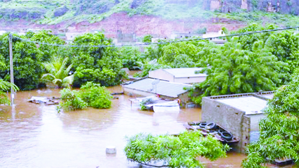
The OMVS has activated its orange code for all peripheral towns of the Senegal River, after announcing that Manantali has reached its maximum level of exploitation. Which means that the risks of flooding are becoming more significant.
The Organization for the Development of the Senegal River (OMVS) reported in a press release that « the Manantali dam, which plays a crucial role in flood regulation (excluding Falémé and Bakoye), is currently at its maximum operating level. » According to OMVS, « it reached the normal management level of 208.05 m IGN on October 3, 2024 and following heavy rainfall in the upper basin, this level rose to 208.28 m IGN on October 13, 2024. » Thus, « in accordance with the safety and operating instructions for the structures, the releases at Manantali will fluctuate around 2000 m3/s (in addition to the flows coming from the Bakoye 850m3/s and the Falémé 1500m3/s) ». According to the forecasts, at Bakel the flow is estimated at 5283m3/s on October 14, at 5836m3/s on the 15th, at 5751m3/s on the 16th. The flow will reach 5426m3/s on the 17th and 4741m3/s on the 18th of this month. During this entire period, the water height will be estimated at 10 to 12m. Consequences, informs the Omvs, « the alert levels will be exceeded in all the stations of the valley of the delta of the Senegal River and floods are possible in the zones not usually subject to flooding ».
Distress Floods: River Senegal Overflows
The organization emphasizes that « in accordance with the instructions for implementing the Senegal River alert plan, the orange alert is activated in all peripheral cities of the Senegal River. » Similarly, they maintain that they are monitoring « very closely the evolution of the current hydrological situation of the Senegal River marked by exceptional rainfall leading to significant flows on the Senegal River. » Moreover, « the flows recorded in recent days are comparable to those observed during the exceptional flood of 1999. »
Read the column – The trivialisation of vulgarity
Faced with this situation, the OMVS indicates that it « has an alert plan integrating the latest hydrological data and the potential impacts of climate change ». This plan, it notes, « covering the entire Senegal River basin, includes maps of flood zones for different flood occurrences, specific alert thresholds for each zone to trigger appropriate preventive actions, an alert dissemination plan involving national and local authorities, flood control committees and the media ».
The State provides basic services
It should be recalled that several villages in the departments of Bakel and Matam are cut off from the rest of the country due to severe flooding caused by the unprecedented high levels of the Senegal River and the Falémé. The Minister of the Interior visited them. However, the situation remains extremely difficult in Bakel, particularly in Yefera, a village located in the commune of Balou, which is completely cut off from the rest of the country. For the time being, the State is delivering tents and food to assist the victims.
By Dieynaba KANE / dkane@lequotidien.sn